St Petersburg, Florida: Hurricane Ian’s most damaging winds has begun hitting Florida’s southwest coast, lashing the state with heavy rain and pushing a devastating storm surge after strengthening to the threshold of the most dangerous Category 5 status.
Fuelled by warm waters in the Gulf of Mexico, Ian grew to a catastrophic Category 4 hurricane on Tuesday night (US time) with top winds of 250km/h, according to the National Hurricane Centre. The storm trudged on a track that would have it making landfall north of the heavily populated Fort Myers area, which forecasters said could be inundated by a storm surge of up to 5.5 meters.
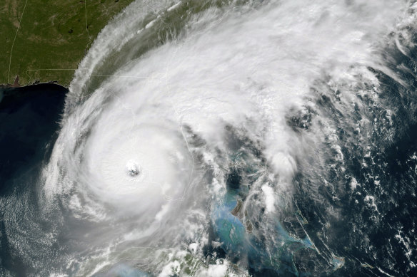
This GOES-East GeoColor satellite image shows the eye of Hurricane Ian approaching the southwest coast of Florida.Credit:National Oceanic and Atmospheric Administration via AP
“This is going to be a nasty nasty day, two days,” Florida Governor Ron DeSantis said, stressing that people in Ian’s path along the coast should rush to the safest possible shelter and stay there.
Cuban officials said they had begun to restore some power Wednesday after Hurricane Ian knocked out electricity to the entire island while devastating some of the country’s most important tobacco farms when it hit the island’s western tip as a major storm.
At least two people were reported killed.
“It was apocalyptic, a real disaster,” said Hirochi Robaina, owner of the farm that bears his name and that his grandfather made known internationally.
Ian’s centre was about 40 kilometres west of Fort Myers at 2pm. Wednesday, as it churned toward the coast at 15km/h. The storm was expected to spend a day or more crawling across the Florida peninsula, dumping flooding rains of 30 to 45 centimetres across a broad area, including Tampa, Orlando and Jacksonville.
Catastrophic storm surges could push 3.6 meters of water or more across more than 400 kilometres of coastline, from Bonita Beach to Englewood, the hurricane centre warned.
“It’s going to get a lot worse very quickly. So please hunker down,” DeSantis said.
Off the coast on Sanibel Island near Fort Myers, swirling water covered residential streets and was halfway up mailbox posts by mid-morning. Seawater rushed out of Tampa Bay, leaving parts of the muddy bottom exposed, and waves crashed over the end of a wooden pier at Naples.
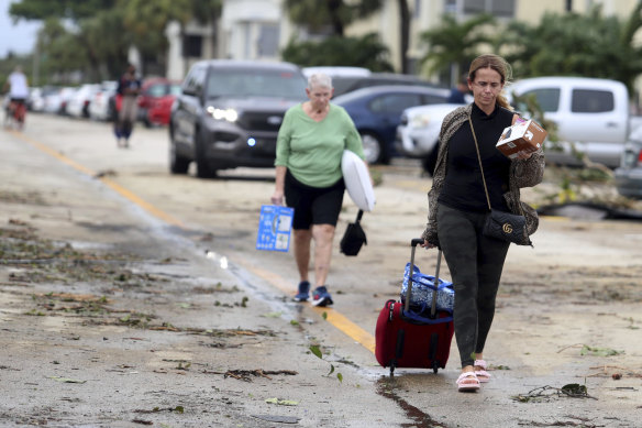
King Point residents leave with their belongings after a tornado connected to Hurricane Ian.Credit:AP
Ian’s rapid strengthening prompted Fort Myers handyman Tom Hawver to abandon his plan to weather the hurricane at home and head across the state to Fort Lauderdale.
“We were going to stay and then just decided when we got up, and they said [250km/h] winds,” Hawver said. “We don’t have a generator. I just don’t see the advantage of sitting there in the dark, in a hot house, watching water come in your house.”
More than 2.5 million people were under mandatory evacuation orders, but by law no one could be forced to flee. The governor said the state has 30,000 linemen, urban search and rescue teams, and 7,000 National Guard troops from Florida and elsewhere ready to help once the weather clears.
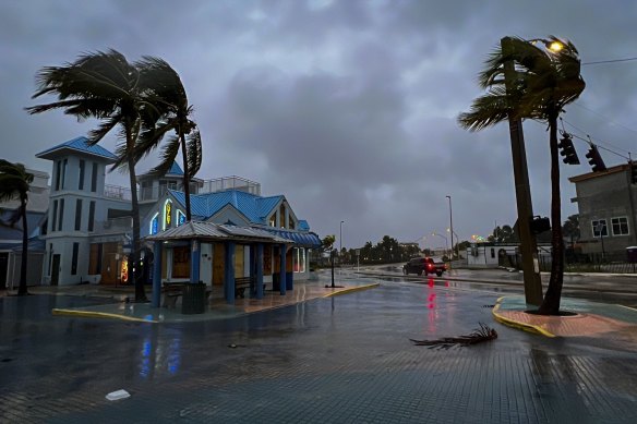
Fort Myers Beach on Wednesday.Credit:Bloomberg
Florida residents rushed ahead of the impact to board up their homes, stash precious belongings on upper floors and join long lines of cars leaving the shore.
Some chose to stay and ride out the storm. Jared Lewis, a Tampa delivery driver, said his home has withstood hurricanes in the past, though not as powerful as Ian.
“It is kind of scary, makes you a bit anxious,” Lewis said. “After the last year of not having any, now you go to a Category 4 or 5. We are more used to the 2s and 3s.”
Forecasters predicted Ian would make landfall more than 1160 kilometres south of Tampa and St Petersberg, likely sparing the densely populated Tampa Bay area from its first direct hit by a major hurricane since 1921.
Officials warned residents that Tampa could still experience powerful winds and up to 50 centimetres of rain.
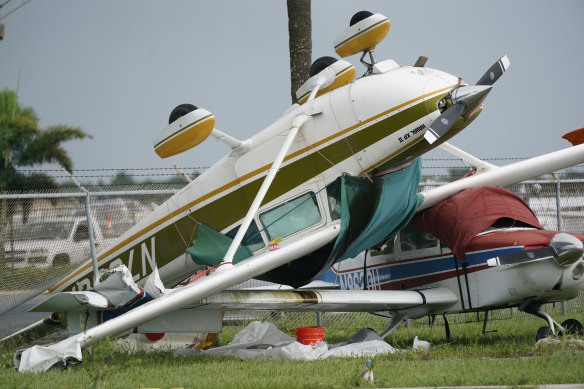
An airplane overturned by a likely tornado produced by the outer bands of Hurricane Ian in Florida.Credit:AP
“Please, please, please be aware that we are not out of danger yet,” Tampa Mayor Jane Castor said in a video on Twitter. “Flooding is still going to occur.”
During the night, Ian went through a natural cycle when it lost its old eye and formed a new one. The timing was bad for the Florida coast, because the storm got stronger and larger — 193km/h to 250km/h — with landfall just a few hours away.
The size of the storm also grew, with tropical storm force winds extending 280 kilometres from the hurricane’s centre.
“With the higher intensity you’re going to see more extensive wind damage,” University of Miami hurricane researcher Brian McNoldy said. “The larger wind field means that more people will experience those storm-force winds.”
The most damaging winds could hit a coastline where the population has jumped sevenfold since 1970.
Ash Dugney warily watched ocean water being sucked out below a Tampa Bay pier on Wednesday morning. He said he didn’t trust Tampa’s storm drainage system to keep his corner tuxedo rental business safe from flooding that he said has happened even during mild storms.
“I don’t care about the wind and the rain and the stuff like that, I just care about the flooding,” Dugney said, adding that he moved essentials out of the shop and moved other items up to above waist-high level.
AP
Get a note directly from our foreign correspondents on what’s making headlines around the world. Sign up for the weekly What in the World newsletter here.
Most Viewed in World
From our partners
Source: Read Full Article